Tuesday, May 3, 2011

From the mountains to the deserts


http://commons.wikimedia.org/wiki/File:US_humvee_crossing_a_small_river_in_Afghanistan.jpg
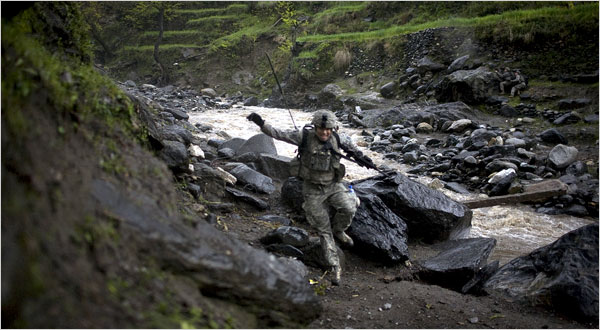
On the right side of this photo, the difference in depths can be seen in the river. The thalweg is the darker, deeper part of the river. The sandy/rocky area on the right is the pointbar.


Thalwegs are formed when the fast flowing water of a stream or river cuts at the riverbed. Thalwegs are the deep parts of the river where the sediment has been stripped away. As the sediment is stripped away, it is carried down river and dropped in slow areas of the river. This is what creates a point-bar in a river. The sediment is dropped in the low velocity areas of the stream, as it collects it creates point-bars.


http://www.flickr.com/photos/11398985@N05/2157126685/
As you can see, when it is possible, this river meanders from side to side due to the high velocity water cutting at the edges of the river.


As the point-bars push out, the direction of the high velocity portion of the stream pushes out as well. This cuts away at the outside edge of the stream/river. Continuation of this causes the river to meander from side to side, creating meander scars.


http://indexresearch.blogspot.com/2008/05/water-world-crisis.html
Northern Afghanistan is pushed right up against the Tibetan plateau. This range is known as the Hindu-kush mountains. This range contains a glacier.


Areas with constant amounts of snow and cold weather allow for the formation of glaciers. As the snow builds and builds, it gradually becomes more dense eventually creating glaciers. As the years go by, the glacier density changes from alpine firn, to polar firn, and finally to blue glacial ice.


http://connect-afghanistan.org/?page_id=18
South-West Afghanistan is a very dry, arid climate. This is defined by a general lack of moisture. The demand is much greater then the supply of moisture. There is also a lack of plant growth, typically under 25%.


AridMapWorld-NonPolar
http://fast.ucdenver.edu/case/1202/Landscapes/Arid/AridLandscapes.htm
As this map shows, taken from Professor Allen's lecture, the lower portion of Afghanistan is located in a climate categorized as "Arid."


Much of Afghanistan can be classified as an arid climate. Located at the base of the Tibetan plateau, Afghanistan’s arid climate is cause by many things. Because it is landlocked, it is far from large sources of moisture. It is also located on the leeward side of the Himalayas. 


For soldiers working in the Southern portion of Afghanistan, the dry, arid climate creates difficult conditions. For the locals that live near these rivers, life can either be frustrating or good (depending on which side of the river they live on). If a person owns the cut bank side of the river, they will gradually loose land, but if they own the point-bar side of the river, they will gradually gain land. Having looked closely at the different areas of Afghanistan in these blogs, and having lived there, I can safely say that Afghanistan is a difficult place to live in. The unforgiving mountains and desert areas of Afghanistan present a lot of difficulties to the people that live and work there.

Thursday, April 7, 2011

Clouds, fog, and so much more...


http://contest.afghanistanmatters.com/?cat=31
This photo of the Bagram valley, shows valley fog. Valley fog is formed by large amounts of moisture, clear skies, and little wind.

Radiation fog forms close to the ground. As the warm air rises, it allows for the cool air to roll down from the surrounding high points.


http://www.universetoday.com/
These cumulonimbus clouds over Afghanistan can produce lightning, thunder, and hail.


Cumulonimbus clouds are formed when a cool air front comes into contact with moist, hot air.


http://www.militaryphotos.net/
This photo taken at an outpost in Afghanistan, shows large amounts of hail, all formed by the repetition of rapid freezing and slight melting of water.

As the warm air current pushes the pellets up, they freeze. As the cold air current pushes the pellet down, it melts. This process is repeated multiple times to form hail.


http://gazingattheflag.blogspot.com/
Photo taken of the Bagram Airfield shows lighting hitting the ground outside of the base.

As a storm begins to dissipate, air pockets between the cloud and ground continue to hold a charge. This allows lightning to connect with the ground, moving from pocket to pocket.

Thunder produced at the same time as the lighting is produced from the rapid expansion and contraction of air due to rapid increase in heat. This expansion and contraction produces sounds waves, causing thunder.

All of these forms can have deadly consequences on the inhabitants of the area. They have the ability to cause damage to humans and random objects that get in their way.

Thursday, March 3, 2011

Deserts and Rivers


Debris flow in Afghanistan taken from youtube.com. As the video shows, these flows move with tremendous speed and force.


This flow was created by mass wasting due to large amounts of rain. As the rain breaks away at the rocks and hillside, the debris along with water flowes into the river in large amounts. 

This soldier is running through a riverbed with great examples of slides along the banks (found on captainsjournal.com)

As the flow passes through the riverbed, it softens the walls of the valley, allowing for slides later on, but it also pulls away at the edges, widening the valley more and more each time.


This alluvial fan in N. Afghanistan, found on io9.com, is a depository for large amounts of sediment.


This debris flows down the river until it reaches a point where it is able to spread out into an alluvial fan. These areas are prime farmlands. The flow of debris brings with large amounts of nutrients perfect for farming.


As shown in this map, from Professor Allen's lecture, S.W. Afghanistan’s soil is largely made up of aridisol. which is low in nutrients and high in calcium carbonate in the B horizon.

Aridisol is dry and low in nutrients, just as the name says, the soil is “arid.” The lack of rain and high temperatures in this area allow calcium carbonate to build up in the soil turning it “toxic” making plant growth scarce.

MARJA, AFGHANISTAN - SEPTEMBER 29:  Sand dunes are carved in the desert September 29, 2010 near Marja, Afghanistan. U.S. , coalition, and Afghani troops continue to suffer losses in the region, once a Taliban stronghold, mostly from IED attacks and sniper fire.
These sand dunes, picture found on features.rr.com, were created from the loose aridisol blown into rifts.

This dry soil is easily eroded and broken away due to wind. This in turn allows for the formation of sand dunes.

All of these forms have large effects on the inhabitants. It can either create harsh and dangerous conditions or it can allow for great growth.

Tuesday, February 15, 2011

Post #1: Korengal Valley

A large majority of Afghanistan is made up of mountains. While all of Afghanistan lies within the Eurasian Tectonic Plate, the mountains of Afghanistan are the trailing end of the NW Tibetan Plateau. These mountains were formed from the converging of the Eurasian and Indian Tectonic Plates.


This drawing shows the multiple plates that make up our Earth's mantle. Drawing taken from
pep.bc.ca

The compression of these two plates also led to the formation of the many valleys that make up Afghanistan's mountain range.


On this map, from topnews.in, the rippled look of central Afghanistan can easily be seen.

Within the mountains of Afghanistan lies a specific area of interest, that area is the Korengal Valley. Within this valley lies many geological formations. One of which is the abundance of shale.


From the documentary Restrepo


If you look to the right of this soldier, you will see large amounts of shale. The shale was first created on the ocean floor, but subsequently made its way to the mountains. This possibly could be result of convergence. As the plates collided, what was once under the water was pushed to the surface. The shale was created from clay on the ocean floor.


discovermilitary.com

The angle of the rocks in this photo are the possible result of faulting.

All in all, the terrain of the Korengal Valley greatly affects the people that are there. For soldiers, it creates a tough and unforgiving environment to fight in. And for the people that live there, it creates a difficult land to live off of. It is for this reason that many farmers of the area strip away at the land to create flat areas to plant seed.


From commons.wikimedia.org

Wednesday, January 26, 2011

An Introduction to the Diverse Land of Afghanistan

I chose to blog about a land that has much significance in my life. I lived in Northern Afghanistan just after the fall of the Soviet Union and right up until the Taliban to control. Being in the Army, I anticipate that I will eventually return to Afghanistan. With this in mind, I chose Afghanistan so that I would be able to get a better understanding of where I have been, and where I might be in the future. I think Afghanistan is a beautiful country, from the flat lands in the South to the towering mountains in the North, Afghanistan is nothing but an awe inspiring and diverse landscape.